A quiet presence for your space, with the movement of nearby aircraft at its heart. LiveSky is exploring what an aviation display can feel like when curiosity comes first.
01 / The idea, in viewDesign study · Synthetic traffic · Not a product photograph
The current software
An invitation to look closer.
The prototype brings together a circular view, aircraft information, and touch exploration. These interactions are implemented in the shared display software; physical-board validation is still ongoing.
01 / Discover
A little more than a dot
Tap an aircraft, even an unlabelled one, to open its information card. Available details include callsign, registration, aircraft type, ground speed, barometric altitude, ground track, and position age.
Missing values stay unknown. Unavailable routes are omitted. Close the card or tap outside it to return to the same view.
02 / Explore
Follow your curiosity
Pinch from 1× to 3×, then drag to explore within the covered area. The view stays north-up, with aircraft and the available map moving together.
Recenter returns to the configured home without changing the zoom. At 1×, the full view is centered and there is no room to pan.
03 / Understand
Keep the gaps visible
Waiting, live, delayed, and offline states make data freshness visible. Individual positions have their own age, and old positions fade before disappearing.
Short, bounded position estimates are visibly distinguished from recorded observations. Fictional traffic never replaces a failed live feed.
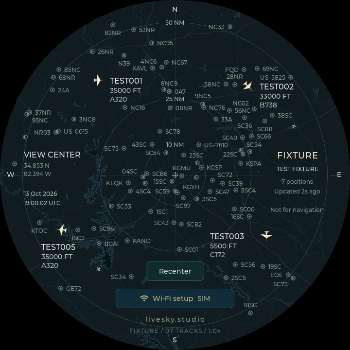
02 / The current rendererActual SDL/LVGL capture · Synthetic fixture traffic · Not a product photograph
A place to begin
One local map. A wider horizon.
The bundled map starts in Greenville, South Carolina, with regional airport and heliport markers. It is a generalized, offline map for exploring the view.
A custom home location can be set in the prototype configuration. It shows traffic around that home, without the Greenville basemap or airport overlay. Worldwide map coverage is not part of the current prototype.
From here, forward
Taking shape. Still in progress.
The ambition is a thoughtful, ambient object for everyday spaces. The current work is a software and hardware prototype built for a 720 × 720 circular touchscreen, with the same LVGL renderer in its desktop preview.
The finished enclosure, final specifications, price, and availability have not been announced. LiveSky is not currently available to buy.